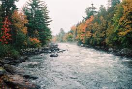
Gasperaux River (Mira) Restoration
ACAP Cape Breton installed 14 structures (digger logs and deflectors) along a 378m length to restore natural stream shape and create pools. Tree planting was completed using 3000 willow trees along 200-400m of riverbank, to increase bank stability and help with the sedimentation problem in the river. Temperature data loggers were placed in the two watercourses for 10 consecutive days to record air and water temperatures. Several other streams and rivers in the watershed were monitored.
Location:
Latitude: 45° 55' 4.228" N
Longitude: 60° 19' 50.642" W
Longitude: 60° 19' 50.642" W
Watershed reference:
Mira